To the west of Buena Vista, and then to the south of the historic mining town of St. Elmo, you can find wonderful hikes along the Colorado Trail. These hikes are especially gifted with wildflowers and views. Fortunately, the hike described here doesn’t require high clearance or 4WD, just sense and patience driving on washboarded dirt roads.
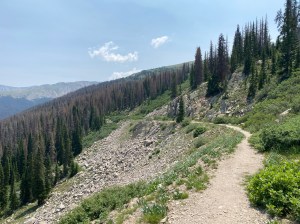
Trail Description: This is a surprisingly easy hike to the east portal of the Alpine Tunnel and then a more challenging hike onward to Tunnel Lake. Your hike starts at the Alpine Tunnel Trailhead at the Hancock Townsite. After hiking about 0.7 miles, you’ll join the Colorado Trail, heading trail east (but actually hiking toward the west here). The trail follows the old railroad track, making for a pleasant, wide path. Of course, a railroad track is typically a gentle grade, so the trail is a delightful hike at high elevation, without seeming like a strenuous climb. Along the way, stop to read the signage that explains some of the history of the railroad. You’ll find yourself walking across the old railroad ties that are slowly decaying. Hikers will also notice the predominance of dead evergreen trees in the valley below the trail. A beetle infestation was devastating to the forest here. However, if you focus your mind on the smaller green trees, you will quickly realize that the forest is already coming back from the beetles. The thinning of the forest has also dramatically increased the wildflowers in this area. Let’s just hope the dead trees don’t lead to a cataclysmic forest fire here.

After hiking about 3 miles, you’ll come to a sign that points to the left, toward Tunnel Lake. Before you head in that direction, continue straight for about 200 yards along the rail line to get to the East Portal of the Alpine Tunnel. There is signage that tells the story of the Tunnel, and, further along, signage that talks about the worker’s living conditions. Rockslide have completely buried the entrance to the tunnel.
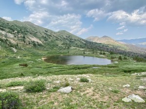
If you want more of a challenge and a longer hike, continue to Tunnel Lake. From the East Portal spur and sign that points the way to Tunnel Lake, you’ll begin a steep climb across a scree field. Just about at the top of this climb you’ll find directional signage that points west toward the West Portal of the Alpine Tunnel. If you’re curious about that trail, head in that direction for a short distance to enjoy the view down into the next valley (see photo on right). Note the old buildings on the valley floor and road headed to the tunnel. Unfortunately, that road is now closed due to rockslides, so it’s a long hike to the West Portal if you come from that valley.
Continuing to the west (“trail east”) from the directional signage, you’ll climb your last challenging vertical to get to the high point of the hike. From here it’s a pleasant rolling hike across the high alpine terrain above tree line. Eventually you’ll spot Tunnel Lake off to the right, almost at the top of Tunnel Gulch. At this point it’s your choice how far you hike to get your preferred view of the lake. There doesn’t seem to be a trail to the lake, so until there is a designated way to get to the lake, just enjoy the views and the wildflowers, which are abundant in the area. When you’ve had your fill, turn around and head back to your vehicle.
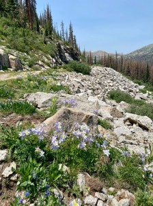
Features: Gentle grade at high elevation to the East Portal, but a more challenging grade to see views of Tunnel Lake. The wildflowers in July are spectacular. Signage explains the history of the railroad and tunnel.
Terrain: Extremely easy railroad bed and then more challenging hiking on a rocky and narrow trail. High elevation.
Difficulty: Easy-Moderate to the East Portal. Moderate-Difficult the rest of the trail to Tunnel Lake.

Getting There: From Buena Vista, head south on 285 to Nathrop. Turn west (right) on Chalk Creek Dr./162, toward St. Elmo. Pass Mt. Princeton Hot Springs and 3 Forest Service Campgrounds. After Cascade Campground the road becomes a well-maintained dirt road. Just before reaching St. Elmo, take 295 to the left (there is good signage directing you to Hancock and the Alpine Tunnel.) Take this well-maintained dirt road about 5.5 miles to the old Hancock Townsite and Alpine Tunnel Trailhead. It’s just over Chalk Creek. Note that there are a lot of ATVs along 295, so be courteous and patient.
Parking: There are a dozen or so parking spots at 38.6393, -106.3618. Arrive early to get a parking spot at the tailhead. If the parking is full, try going back across the bridge over the creek to find parking at the old Hancock townsite.
Length of Hike: About 9 miles total, but only about 6.2 miles of gentle trail if you just go as far as the East Portal.
Elevation: Trailhead: 11,058. High Point: 12,000.
