Marshall Pass is a hidden gem tucked away from the crowds you find on Monarch Pass. Whether you are camping in the area or hanging out in Salida or the San Luis Valley, a day trip to hike from the Pass is a great way to enjoy the mountains. Unfortunately, like so many places in Colorado, the pine beetles have done a lot of damage to the forest, so keep your focus a bit lower, enjoying the wildflowers and interesting minerals along the trail.
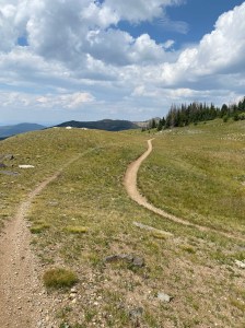
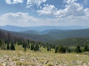
Trail Description: The trail starts just across the road from the east end of the parking lot. In general, this trail is a steady, gentle uphill climb. The first 1.2 miles is a narrow road which ATVs are allowed to use. Since it is a dead end for them, there isn’t a lot of ATV traffic but do be aware. There are a couple of rocky patches on this stretch of the trail, but the limited ATV use means most of the trail is a nice hard packed dirt with a few rocks. The forest here is fairly dense but has enough gaps to support lots of flowers and the occasional view across the valleys to your left. At the 1.2 mile mark where the trail narrows to a single track (no more ATVs!) there is an interesting mineralized hill with quite a bit of large mica flakes and “books” of mica flakes. The remainder of the hike is on trail which allows “dirt bikes” but again the motorized traffic if likely to be minimal, especially during the week. At the 1.9 mile point, the forest opens up entirely as the trail crosses a large scree field/meadow. The flowers are different here, the views are broader, and you are likely to spot a marmot or little pika. It is a bit of a taste of what comes at the suggested end of this hike. At this point the trail is at about 11,600’ elevation. Just after the 2.6 mile point, the trail meets the Agate Creek which heads downhill and the Cochetopa Trail heading uphill is a few steps further. Continuing out into the field beyond these side trails, the path reaches treeline. A few steps up to the hummock (11,800’ elevation) on the left side of the trail opens up the view dramatically and provides a great spot for a snack or lunch before heading back. Be sure to enjoy the alpine flowers too. The hike back is easy and relatively quick since it is virtually all a gentle downhill. Enjoy the flowers, the way the views change going the other way and look for in-season berries to nibble as you trek along.
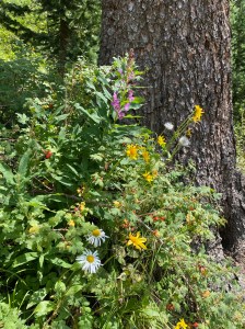
Features: Wildflowers in early summer, wild strawberries, wax currants, mushrooms and huckleberries in mid-August. Interesting minerals, including quartz and mica. Broad views at the high point of the hike.
Terrain: Forested hiking uphill. At first the trail is on an ATV “road” and then it transitions to a single-track. Mountain bikes and motorized dirt bikes are allowed so keep your wits about you. We were pleasantly impressed at how polite everyone on the trail was and hope you have the same experience.
Difficulty: Moderate to difficult
Getting There: From Poncha Springs (which is south of Buena Vista and west of Salida), drive 4.9 miles south on US Hwy 285. Turn right onto Marshall Pass Rd. Drive 2.3 miles and turn right to stay on Marshall Pass Rd. Drive another 0.9 miles and turn right again to stay on Marshall Pass Road. In about 11 miles you’ll arrive at the Marshall Pass parking area. There is dispersed camping along Marshall Pass Road and a campground nearby at O’Haver Lake. Marshall Pass Road is a well-maintained dirt road so this 19-mile drive from Poncha Springs will take “just” 47 minutes in any vehicle.
From Gunnison, head east on US-50 for about 30 miles. Turn right onto County Road XX32 then FR-243, also known as Marshall Pass Road. Drive 17 miles to the pass.
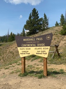
Parking: Just east of the actual Marshall Pass there is a parking lot with room for a dozen cars, signage and an outhouse at 38.3950, -106.2473. There is additional parking space near the sign at the actual pass (just west of the toilets, etc around a bend), and uphill from the pass on a little side road.
Length of Hike: 5.5 miles roundtrip
Elevation: Trailhead: 10,841. Turnaround in the field just past Agate Creek Trail Junction: 11,798.
