This busy trail provides an opportunity for some exercise while taking in views of the Blue River Valley between Breckenridge and Frisco. The Gold Hill Trailhead is popular among locals as well as tourists, since it not only provides access to the Colorado Trail, but it also provides bikers with access to the Recreation Path that runs between Breckenridge and Frisco. You may also meet CT through-hikers who catch the free Summit Stage bus from this trailhead to take a break in town for a soft bed and slice of pizza (or maybe a whole pizza!)
Trail Description: From the trailhead, start hiking uphill to the west. After hiking about a half mile, you might notice that the trail takes a slight turn to the left to switchback up the hillside. If you pay close attention, you’ll see that the trail used to go straight up the hill from here, but it has been moved due to erosion. We think the shift of the trail to these switchbacks are the reason that your experience of the hike will be that it is slightly longer than the mileage on the signs you’ll find at the trailhead and at the intersection with the Peaks Trail. The Forest Service signage says that the trail is 3 miles from the Trailhead to the Peaks Trail, but we found it to be closer to 3.25 miles each way.

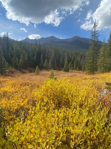
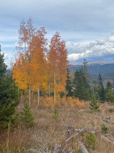
Thanks to the damage caused by the mountain pine beetle, much of the forest has been cut in this area. While the stumps and cleared hillsides may be jarring, these measures were necessary to prevent forest fires in an area close to neighborhoods and the highway. These types of fire prevention practices provide an opportunity for wildflowers to thrive on the hillsides and for new, healthy pine trees or aspen to begin to grow. As you hike, notice how some areas have new trees that may be 4 to 6 feet tall, where other areas were cut more recently and only have wildflowers growing so far. The advantage of all of this clear-cutting is that the views of the Blue River Valley are unobstructed and magnificent.

After the first mile or so, you’ll hear less of the highway and find more peace and quiet. Watch out for mountain bikers who frequent the area. About 2.8 miles into the hike, you will reach a high point on a ridge. Go far enough along the trail to enjoy the views of the Ten Mile Range to the west. From here, it’s almost another half mile to the intersection with the Peaks Trail. Unfortunately, the CT goes downhill to the Peaks Trail. So, unless you want a longer hike and are all right with the hike back uphill, there’s not much reason to continue to the Peaks Trail. The views don’t get any better and there’s nothing special to see. If you do want a longer hike, you could hike a bit of the Peaks Trail to the south or take it all the way north to Frisco and then catch the free Summit Stage bus back toward Breckenridge and disembark at the Gold Hill Trailhead where your vehicle is waiting.
Features: Views of the Blue River Valley to the east and then views of the Ten Mile Range to the west.
Terrain: Much of this trail is across hillsides that have been clear-cut of the pines that had been killed by pine beetles. The trail is eroded in some areas but is in generally good condition.
Difficulty: Moderate.
Getting There: From I-70, take exit 203 for CO-9 south toward Frisco/Breckenridge. Go about 5.7 miles to Gateway Drive, which will be on your right. This is the Gold Hill Trailhead.
Parking: There is parking for several cars at the Gold Hill Trailhead. If the lot is full, do not park along the road. Parking is not allowed along County Roads in Summit County. Instead consider one of the other parking areas just east of here along the CT. You can park along Revette Dr., just south of the Tiger Run RV Resort, where there is an area to pull off the road. Another option is, after turning onto Revette Dr. from Highway 9, travel 0.4 miles to the trailhead with parking on the right at 39.5405, -106.0362.
Length of Hike: 7.5 miles
Elevation: Gold Hill Trailhead: 9,199. Peaks Trail Junction: 9,954.
